Showing posts with label Aomori City Maps. Show all posts

Wednesday, August 11, 2010

Aomori City Directions and Maps

Getting to Aomori City from Misawa Air Force Base via Michinoku Toll Road

My husband and I have driven to Aomori City both via scenic route and toll road. Although Aomori City is only 70km away, it takes about 90-120 minutes vial toll road because there are many winding roads that only permit one-lane each for two way traffic. It cost ¥830 each way (¥1660 round trip) via toll road. The scenic route is free and takes about 2.5 hours.

Since internet maps searches aren't useful to people who cannot read Japanese, I've decided to take photos for directions to the places my family and I visit in hopes of helping others stationed in Misawa City. Misawa Air Force Base offers some written directions and maps to most major tourist attractions, but it's easier to read and look for major landmarks when driving with children in the car. Pictures may appear grey because of inclement weather and not all images were taken on the same day.

1. Go forward out the main gate, through the first traffic light.

2. Turn right at the second traffic light to Aomori/Towada.

3. Continue on this street until it becomes a Y-intersection. Turn right.

4. Go forward and cross White Pole Road (one way street going from left to right).

5. Once you pass the traffic light, you are now on Route 8. The blue road sign will read Noheji 33km.

6. Continue forward past Kamikitacho Station.

7. Turn left at Highway 394. Circle K will be on your right. The blue road sign will read TOLL ROAD (Mi-chi-no-ku is in Japanese hiragana).

8. You are actually on Highway 173 (I know it’s confusing!). Go over the bridge past Maeda grocery store (red & white swan).

9. Very shortly, look for the blue road sign on your right that reads, Michinoku Toll Road. Turn right.

10. Continue going forward on Michinoku Toll Road, past Circle K and the Route 4 intersection. This is the last convenience store and public bathrooms for another 40km.

11. Continue forward. A blue road sign will note that you are on Highway 242: Aomori 40 km. It may feel longer because of the winding, two-lane road. After three tunnels, there will be a toll gate. Pay ¥830 per car and pass another two tunnels to Aomori City.

12. You are now on Route 123. Do NOT enter Aomori Expressway on your left (unless you are in a hurry to get to the city center faster and want to pay extra yen). Stay on this road until it comes to the Route 44 T-intersection.

13. Detail of sign at traffic light. Aomori City: turn left at the intersection. Asamushi City: turn right at the intersection.

14. Continue on Route 44 until you arrive at the Y-intersection (Shell gas station on the right). Aomori City: turn right on to Route 4. Big Buddha: continue forward on Route 44.

15. There will be another traffic light and Japanese blue road sign. Turn left on Route 4 for Aomori City (turn right for Asamushi City).

16. The road is two lanes and will widen to five lanes. Stay in the center and right lanes for Central Aomori. Get in the left lanes for Route 7 to Aomori Museum of Art, Hirosaki City, and Goshogowara City.


I know sometimes it's a hassle asking for and collecting maps from different organizations. So, I've compiled and scanned some maps I obtained from different Japan Tourist Information Centers and other on-line sites.


Click on the map for a larger view.
This Blogger site does not support PDF files so I was not able to upload them. If you would like a copy of the map sent to you in PDF format, please e-mail me.


Aomori City Downtown Map

Aomori City Downtown Map - Dining Legend

Aomori City Downtown Map - Shopping Legend

Aomori City Map

Aomori City Downtown Map - Hotels

Aomori Area Map

Aomori City Downtown Map - Japanese Version

Tuesday, August 10, 2010

Nebuta Matsuri, part two

Saturday, August 7: Afternoon Nebuta Parade

The Tohoku region hosts other Nebuta Festivals in various places; yet, the one in Aomori is the most famous. Every year, over three million visitors flock to Aomori City in the span of six days to watch 20 illuminated floats light the night sky. Another attraction of the Nebuta Matsuri is the very wild dances performed by 100s of male and female participants, called haneto, who march and dance merrily to the sounds of taiko drums and festival music, chanting "Rasse-rah, rasse-rah." Anyone can join the fun as a haneto by renting a costume from a local shop.

The Nebuta Festival takes place from August 2 to 7 in Aomori City. They begin parading along a 2.5-kilometer (1.5 mile) course. Lanterns are illuminated as dusk approaches (around 18:30) evening and finish up around 21:00. The peak comes on August 5 and 6, when the largest number of floats are out. On the final day, August 7, floats begin their procession about one o’clock in the afternoon. After the parade, floats can be viewed at ASPM. Later that the evening, three floats judged to be the best are taken to the sea and placed on ships for a cruise around the port of Aomori and fireworks wrap up the festival.


2010 Nebuta Festival Map Route 1

2010 Nebuta Festival Map Route 2

Be prepared for some VERY crowded conditions. Perhaps the best way to get there and back is by train (¥1280 each way). Although driving is discouraged because of the lack of public parking, we decided to pack the car and two children to head to Aomori City. After all, Kyle and I drove to Pasedena one New Year’s Day to watch a Rose Bowl Tournament Game, so I figured we could brace this crowd. After almost two hours via the scenic route, we arrived at our destination. The roads were closed at the police station on National Road 4, about four blocks from where the route took place, so we were detoured.


Unfortunately, we had a late start – it seems our timing is off with small children – and caught the last half of the parade. When the kids are older, I think I’d like to make this trip again to see the evening parade. The gallantry of the floats is somewhat less regal during the day. Not to mention, taking photos posed somewhat of a challenging because I am short (5'00"), tried to maneuver between people, keep an eye on my sleeping son and belongings, as well as switch between camera and camcorder; Kyle was feeding Talia. Life before children was so much easier, but we've become accustomed to the hustle and bustle. After all, it's only on the weekends, weekdays we stay home.


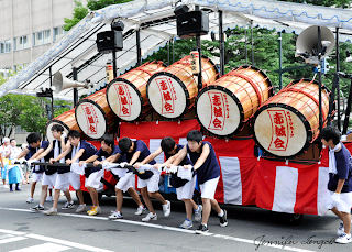
Large taiko drum precede nebuta floats

Backside of drums, followed by musicians and dancers

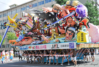
About 30-50 men push the floats around the 2.5 km parade course

It's difficult to image these are enormous papier-mâché floats

Young men and some teenagers underneath float

These guys are dedicated even in sweltering heat and humidity

Sometimes carriers rotate floats so onlookers can get a 360° view

Haneto dancer

Taiko drums configured differently

This was Kyle and my favourite float because it didn't have the traditional Japanese warriors, samuris, and onis. I thought it looked quite majestic.

Small children's floats accompany the larger nebuta floats

XL parade cone to block off traffic. Where do they get these things?


Aomori Tourist and Convention Center
Tel. 017-723-7211
www.nebuta.jp/english/index_e.htm